

Here at saltwedge.org are concepts, perspectives, and activities to enrich the educational experience of the science of New York Harbor, particularly as seen while sailing on schooner Pioneer, or if you can't come along in person, virtual participation over the Web. The basic science can easily be studied, learned, and enjoyed (Science can be FUN!) by doing simple, safe, inexpensive experiments and hands-on activities, using easily obtained materials like water, salt, food coloring, plastic cups, pipe cleaners and thermometers.
Information and Feedback about Pioneer Programs
Here are a few downloadable PDFs listing some Pioneer programs. Please find important information about being prepared for a Pioneer trip. If you've already sailed, click here to fill out a feedback form. ![]()
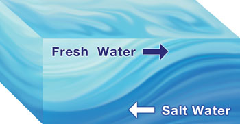
What is a Salt Wedge? If you put salt in water, it sinks to the bottom (try it and see!). Salt sinks because it's denser than water. Likewise, water with some salt in it is denser than fresh water. At the mouth of a river, where the river's fresh water meets the salt water of the sea, the denser salt water sinks under the fresh water. If the waters are moving in opposite directions, the lighter fresh water floats as the denser ocean water pushes in along the bottom in a wedge shape, the "salt wedge", as seen in the accompanying picture.
|